NOAA SYNC LIVE MFL,111,52 · 24HR ... MTR,84,105 · 24HR ... PQR,112,103 · 24HR ... NEXT FORECAST PULL 00:14:52

The Platform

Everything your SWPPP program needs.

From the first drop of rain to the annual report — tracked, triggered, and documented in one place, on any device.

01

NOAA rain tracking

Rain Event Tracker syncs directly with NOAA — the authoritative weather data source under the Construction General Permit — and monitors precipitation continuously for every job site you manage.

  • Per-site rainfall totals, updated in real time
  • Custom thresholds per site and permit
  • Forecast visibility to plan crews ahead of weather
Riverside Commerce Center NOAA · KTUL
0.62 in
Rainfall — last 24 hr
Threshold 0.50 inches — inspection triggered
Last 7 days
FSSMTWT
!

Inspection triggered — Riverside Commerce Center

0.62 inches in 24 hr exceeded the 0.50 inches threshold. Inspection due within 24 hours.

06:14 AM · email + mobile

Approaching threshold — Cedar Ridge, Phase II

0.41 inches and rising. Forecast shows continued rain through 2 PM.

05:48 AM · email

02

Instant notifications

The moment a site crosses its rain threshold, the right people know. Preselected alerts let you send crews and inspectors directly to hot spots — no inbox-watching, no missed windows.

  • Alerts by site, by threshold, by team member
  • Forecast-based heads-up before conditions change
  • Inspection-due reminders with deadlines attached

03

Custom digital forms

In-depth inspection forms tailored to your program — completed and filed from the field on a phone or tablet. No paper, no re-typing, no lost records.

  • Built around your SWPPP and permit requirements
  • Photos, findings, and corrective actions in one record
  • Filed instantly — visible to the whole team
Post-Rain Inspection № 2381 · 06/12
Perimeter controls in place & functional
Stabilized construction entrance maintained
!Inlet protection requires maintenance+ corrective action
Stockpile management — in progress…
Submit inspection
New · AI Photo Analysis

Snap a photo. The inspection writes itself.

Photograph any BMP in the field. The AI identifies the practice, flags deficiencies, and drafts the finding directly into your inspection report — ready for your review before you leave the site.

AI Photo Analysis inspection #2381 · 06/12
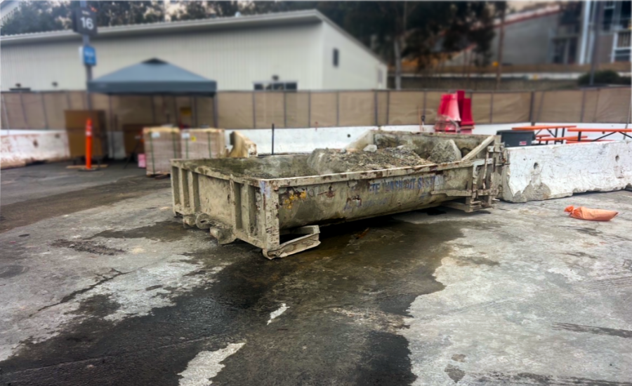
Field photo — job site perimeter control
SE · 06/12 · 11:38
Identified BMPPerimeter control — fence screening
Deficiency
Safety fence section displaced along east excavation edge.
Maintenance
Soil stockpile within 5 ft of perimeter; verify cover or setback.

Suggested action: Re-set displaced fencing; relocate or stabilize stockpile away from the perimeter.

Insert into report

Identifies common BMPs

Silt fence, inlet protection, stabilized entrances, and more — from a single field photo.

Flags what matters

Deficiencies and maintenance triggers surfaced with severity, not buried in photos.

You stay in control

Every finding is a draft until you approve it. One tap inserts it into the report.

Annual Report — 2026 compiling year-round
Rain events tracked47
Inspections completed52 of 52
Corrective actions closed11 of 11
Records exportedReady — one click

04

Annual reporting

Key information is tracked and organized all year long — every rain event, inspection, and corrective action — so your records stay export-ready. When it's time to file, the optional Annual Report Assistance add-on streamlines the report itself.

  • Complete, defensible records per site
  • Export-ready when the reporting window opens
  • No year-end scramble through filing cabinets

Any device. Every job site.

Actionable, real-time NOAA data, digitized forms, and reports on phone, tablet, or desktop — in the field or in the office.

Get started

Try it free for 30 days.

See how Rain Event Tracker transforms the way you manage stormwater compliance — including AI photo analysis. Risk free.

Start your free trial

Full platform access · Cancel anytime